Original piece: 《为全球导航,中国如何做到的?》
Produced by Institute for Planets (星球研究所)
Written by 艾蓝星
Translated by Kelvin Kwok
Posted with permission from Institute for Planets
Two decades of setting up the celestial chessboard
Translator’s comment:
China’s navigation system, BeiDou (literally ‘Northern Dipper’), was named after the seven brightest stars (also known as the Big Dipper asterism) of the Ursa Major constellation, which have long been used for navigation since antiquity by the Chinese civilisation. ‘BeiDou’ therefore serves as the perfect metaphoric name for the modern navigation system.
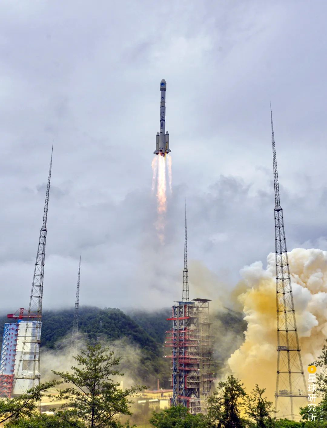
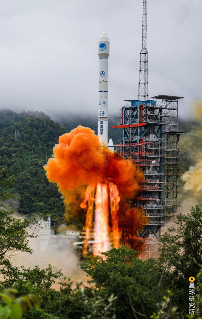
On 23 June 2020, the Long March rocket soared into the sky from the Xichang Satellite Launch Centre, carrying with it the very last satellite of the BeiDou navigation system.

(photo: 南勇)
The satellite will reach its designated orbit located at approximately 36,000 kilometres above Earth’s equator, marking the completion of China’s BeiDou Satellite Navigation System. This comprehensive system is comprised of 46 satellites orbiting around Earth at all times, with more than 2700 base stations scattered across the country providing a blanketing navigation coverage.
It consists of 16 BeiDou-2 and 30 BeiDou-3 satellites
(diagram: 郑伯容, Institute for Planets)
This was an arduous project involving a total of more than 80,000 staff and 300 research and development units, whom together spent more than 20 years to realise their shared dream.
As the only launch system for BeiDou satellites, Long March rockets have accomplished 44 missions over the past 20 years.
(photo: 史悦)
It is also a vital project. Today, the navigation system is widely used in almost all sectors, including power supply, finance, communication, transportation, agriculture, surveying and even disaster relief. With BeiDou in place, China shall become totally independent of the Global Positioning System (GPS) owned by the United States.
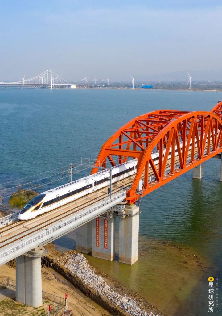
A one-time braking command can achieve a stopping margin of less than 10 cm for a high-speed train travelling at 350 km/h
(photo: 赵斌)
BeiDou also allows precision guidance for missiles, which is the basis for a dependable national defence.

(photo: 人民视觉)
Capable of providing global coverage, BeiDou is now one of the four major global navigation satellite systems (GNSS) in operation, standing in line with United States’ Global Positioning System (GPS), Russia’s Global’naya Navigatsionnaya Sputnikovaya Sistema (GLONASS) and European Union’s Galileo.
Forging away for 20 years, how did China build the BeiDou Navigation System?
1. Satellite Navigation
To determine our location, we need at least 3 satellites.
Each of these satellites constantly emits signals in the form of electromagnetic waves, which are captured by receivers on our navigation equipments on Earth. While electromagnetic waves travel at the speed of light (3×10⁸ m/s), over a vast distance there will still be a time delay between the emission and reception of the signals. Simply multiply this time lag by the speed of light will conveniently inform us about the distance between ourselves and the satellite.
When there is only one satellite, our distance from it becomes the radius of an imaginary sphere with the satellite in the centre. Our position could be any point on the spherical surface.
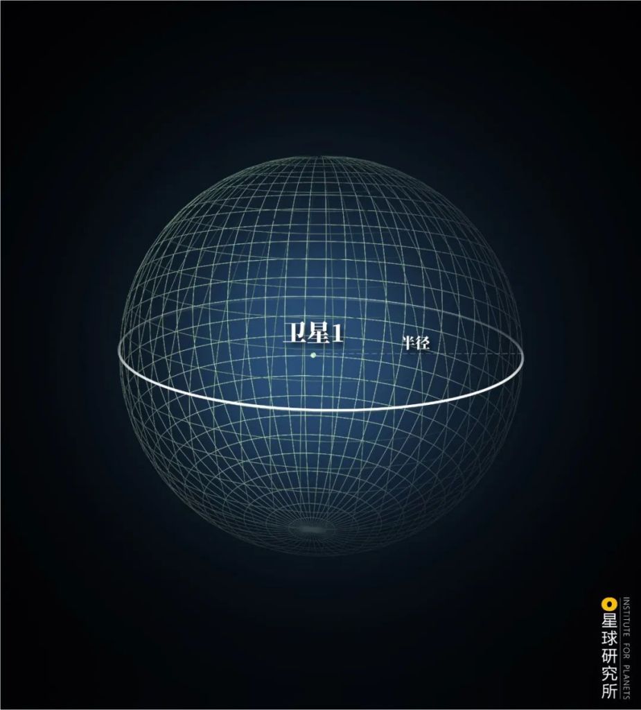
Radius (半径)
(diagram: 郑伯容, Institute for Planets)
Add one satellite and we have two imaginary spheres. They overlap and form a circular intersection. In this case, the entire circumference of the intersection could be our possible position.
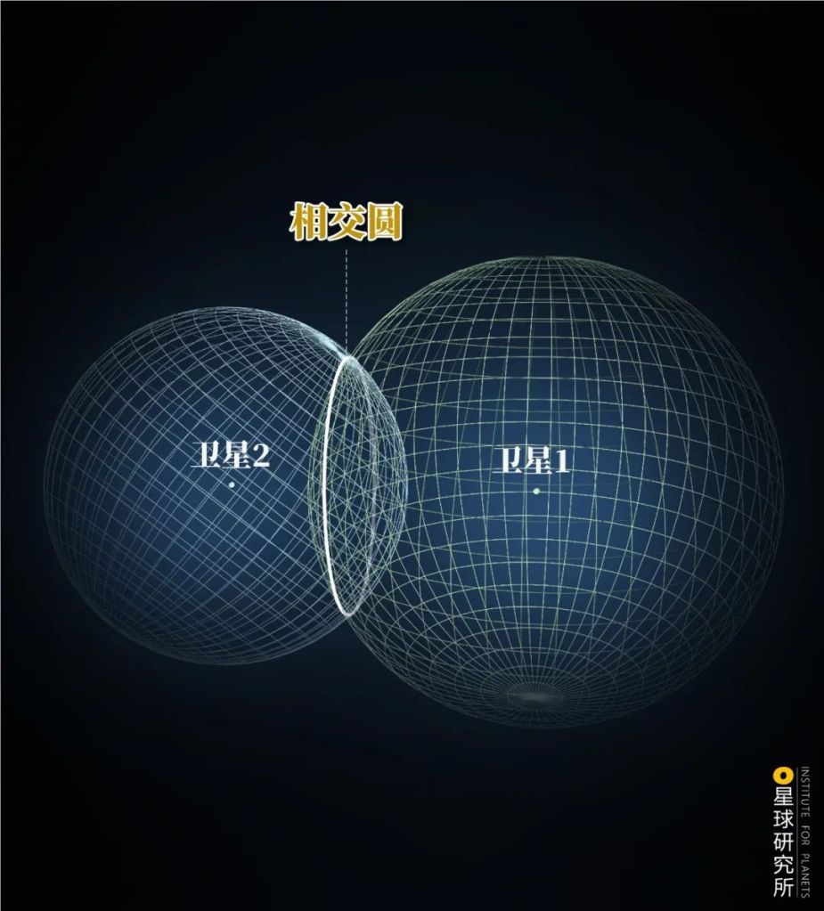
Circular intersection (相交圈)
(diagram: 郑伯容, Institute for Planets)
If all three satellites are present, the intersection of the spheres becomes two exact points – A and B, and we could be located at either one of them.
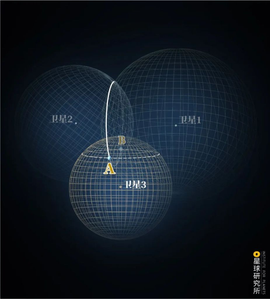
(diagram: 郑伯容, Institute for Planets)
Of the two points here, only B is located on the ground surface and hence indicates our exact position on Earth.
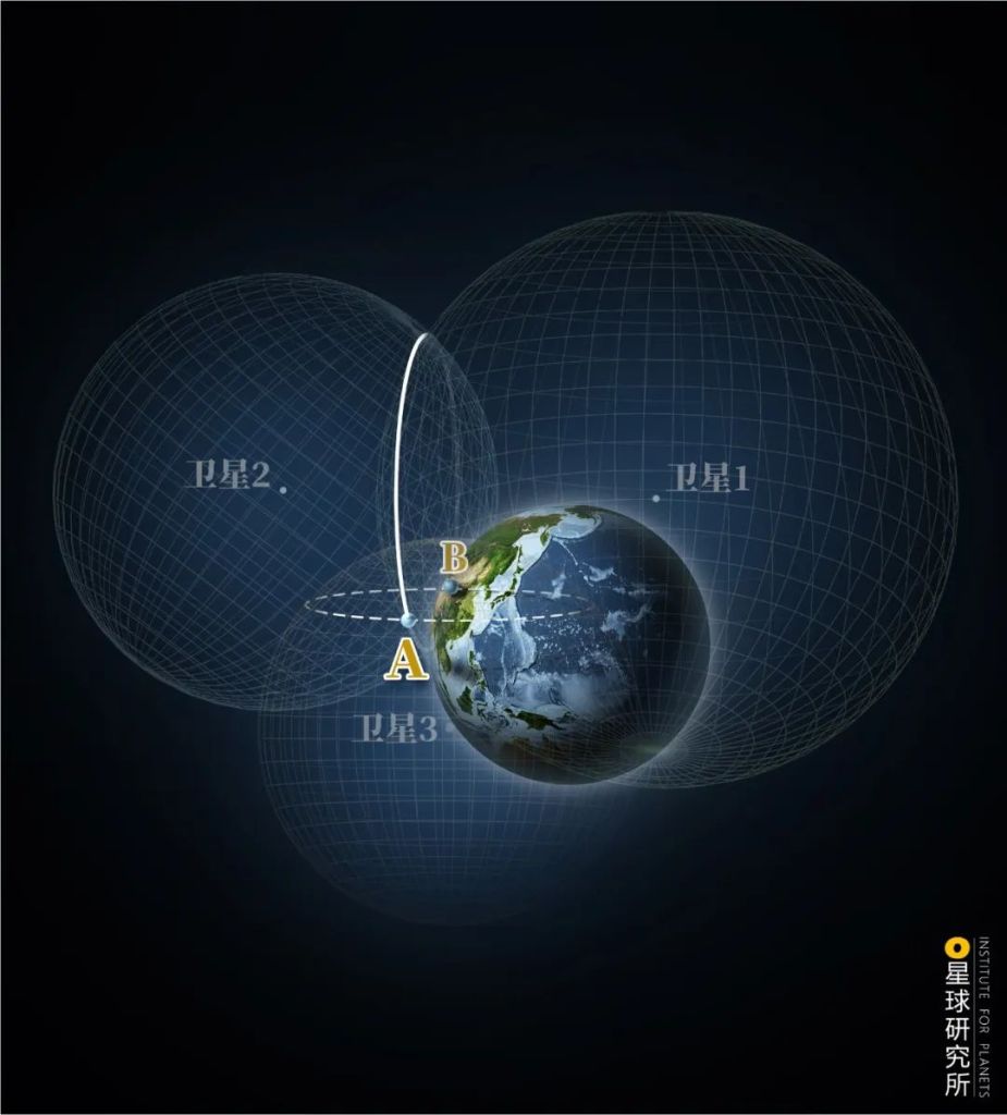
(diagram: 郑伯容, Institute for Planets)
This is the trilateration method, the fundamental principle of satellite navigation.
In reality, deviations in time measurement may arise among the satellites, and hence a fourth satellite is needed to overcome this problem. And to ensure that we can always receive signals from at least 4 satellites, we need far more of them orbiting around Earth. For instance, both GPS and GLONASS are operating with more than 24 satellites.

There are usually more than four satellites orbiting above a specified position at any given time
Orange lines/dots: receivers and visible satellites
Image source: Wikipedia
(diagram: 郑伯容, Institute for Planets)
Unfortunately, China in the 1990s was still lagging behind in aerospace and navigation technologies, and to send similarly large constellation of navigation satellites into orbits within a short timeframe was essentially an impossible task.
Is it possible at all to achieve positioning using minimal number of satellites?
2. A Humble Beginning
You guessed it.
It was a bold proposal.
Conceived by Chen Fangyun, a renowned electronics expert and an awardee of the Two Bombs and One Satellite Merit Award, the proposed navigation system, also known as radio determination satellite service (RDSS), would rely on only two satellites.
The ingenuity in this two-satellite system lies in the establishment of a ground station, which acts as a ‘brain’ on Earth. Using this ground station, engineers are able to simulate the third imaginary sphere on the ground surface, and in turn determine the receiver’s location at the intersection with the other two satellite spheres.
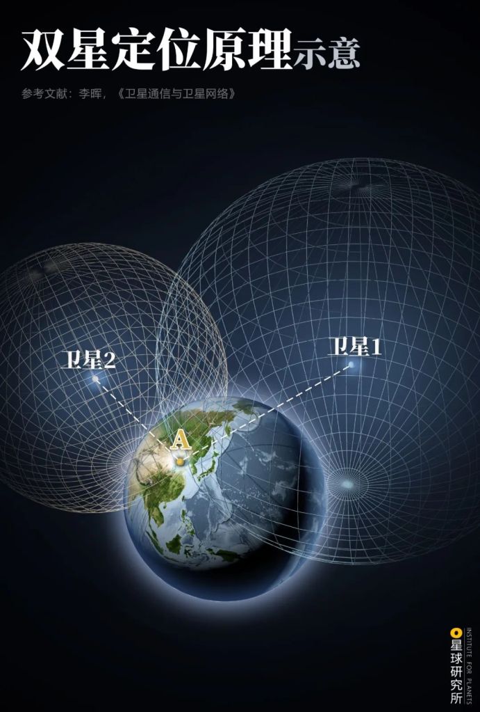
The ground station is equipped with incredible computing power, and is capable of providing data on receivers including altitude
(diagram: 郑伯容, Institute for Planets)
To guarantee persistent signal coverage, the two satellites operate at the stationary orbit, which is 35,786 kilometres above the ground. There they travel at the same speed as Earth’s rotation, hence always hovering above the same area on ground surface.
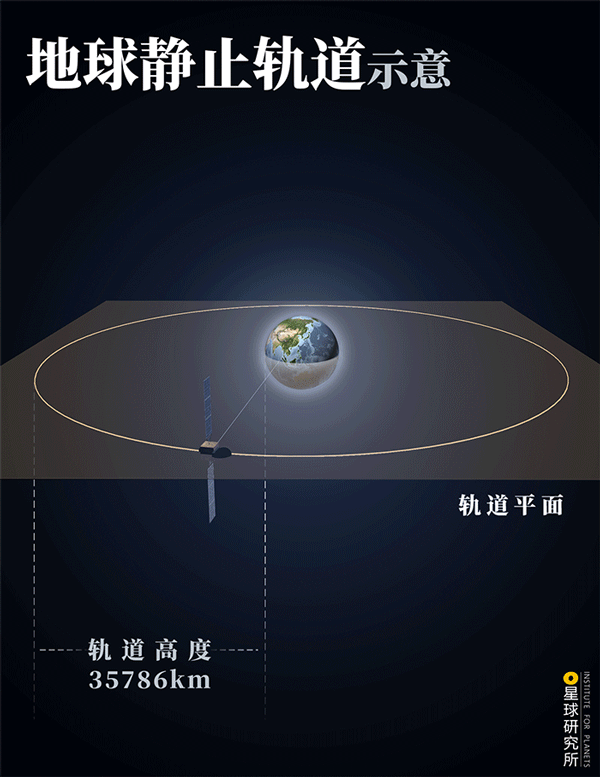
Orbit altitude (轨道高度), plane of orbit (轨道平面)
(diagram: 郑伯容, Institute for Planets)
Since 1994 when the project officially commenced, it took more than 6 years of research and development before the two BeiDou satellites were sent into their orbits in 2000. From then on, a two-satellite navigation system was no longer just an idea.
This is the BeiDou-1 navigation system.
Its signal essentially covers the entire Chinese territory.
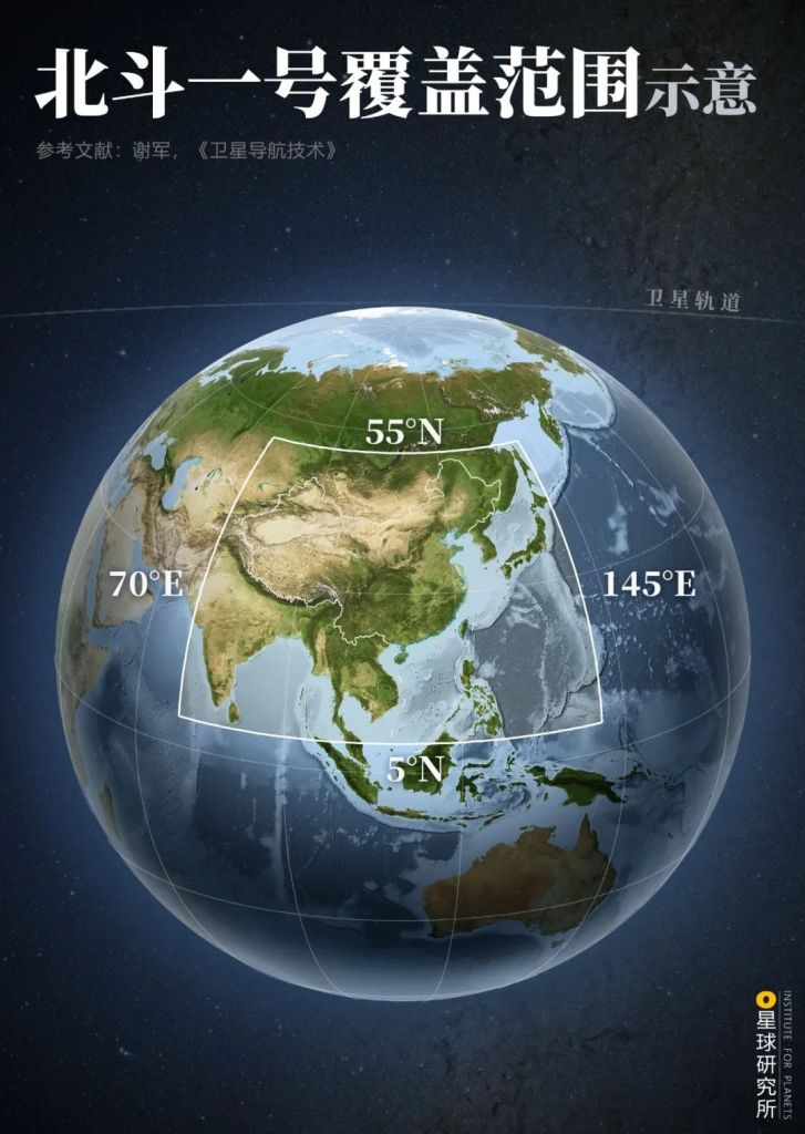
Covered area is from longitude 70°E-145°E and latitude 5°N-55°N
(diagram: 王朝阳&郑伯容, Institute for Planets)
Not only can users receive positioning information from BeiDou-1, but also send out text messages. A two-way communication is critically important for seeking rescue or providing assistance in times of disasters. On the contrary, the GPS is unable to provide such service since it only allows one-way communication like a radio.

Being able to receive positioning information and send out text messages is advantageous especially during disasters like earthquakes or emergencies in remote areas or far oceans
(photo: 贾君洋)
This two-way communication was the first of its kind in the world. Bradford Parkinson, widely regarded as the Father of GPS, also acknowledged this unique design for providing a ‘wonderful experience of knowing where you are, as well as anyone else‘.
However, as an experimental navigation system, BeiDou-1 is not without a list of shortcomings. It has a positioning accuracy of 20-100 metres and a timing accuracy of 20-100 nanoseconds. This is far inferior to GPS back then, which was able to achieve 10 metres and 20 nanoseconds accuracy. Moreover, BeiDou-1 can merely support 150 users at once, and only provides a very limited signal coverage.
While the text messaging function is helpful, it involves cumbersome procedures, and the signal can easily be intercepted. This can potentially lead to approximately 1 second of time delay in positioning as well as unintended exposure of the user’s position, thus is certainly unacceptable for fast-moving objects such as aeroplanes and missiles, and for highly classified military missions.
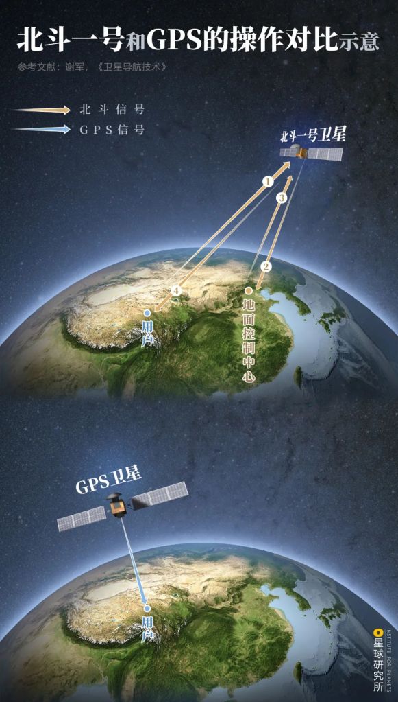
BeiDou-1 (北斗一号卫星), ground station (地面控制中心), user (用户)
(diagram: 郑伯容, Institute for Planets)
Nonetheless, BeiDou-1 turned a new page for China’s navigation system albeit only performing rather simplistic functions. After the initial humble steps, what is waiting ahead for BeiDou?
3. Overcoming Hurdles
The Xichang Satellite Launch Centre has been kept busy since 2010, and within 3 years, a total of 14 satellites were sent up to space right here: 5 of them in 2010, 3 in 2011 and 6 in 2012.

Two BeiDou-2 satellites were launched in 2007 and 2009
(photo: 余明)
And on the ground, engineers wasted no time to set up supporting systems including data processing and control units. Calibrations between the satellites and ground stations were done simultaneously. The end of 2012 was approaching when the BeiDou-2 navigation system was finally completed.
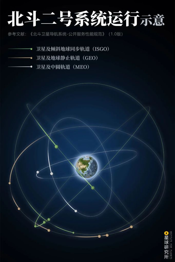
Inclined geosychronous orbit, IGSO (倾斜地球同步轨道); geosynchronous equatorial orbit, GEO (地球静止轨道); medium Earth orbit, MEO (中圆轨道)
(diagram: 郑伯容, Institute for Planets)
Compared to BeiDou-1, it has a much wider signal coverage that reaches most of Asia-Pacific. Positioning accuracy has also been improved from 20 metres to 10 metres, while timing accuracy has reached 10 nanoseconds.
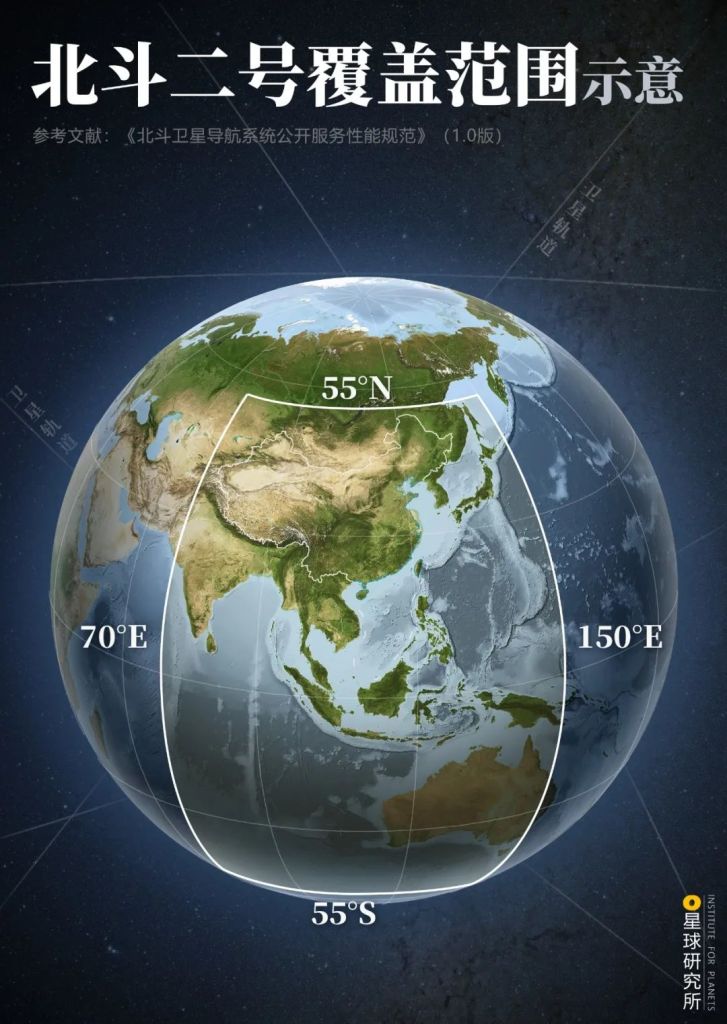
Covered area is from longitude 70°E-150°E and latitude 55°S-55°N
(diagram: 王朝阳&郑伯容, Institute for Planets)
BeiDou-2 also inherited the two-way communication feature from BeiDou-1. With a wider signal coverage, it is able to provide assistance to even more people who are in need.

After the magnitude 8.1 earthquake on 25 April 2015, BeiDou-2 was employed to assist in search and rescue
(photo: 人民视觉)
Upgrading the BeiDou navigation system was not an easy task, as there were major technological hurdles lying in front of scientists.
And here comes the first challenge: configuration for the satellite constellation.
The best orbit for navigation satellite is the medium Earth orbit (MEO) that occupies space at around 20,000 kilometres. Because of the superior global coverage it can offer, other major systems including the GPS are all operating in this orbit.
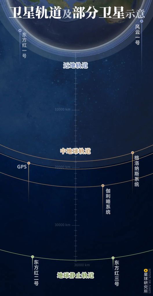
Low Earth orbit, LEO (近地轨道); medium Earth orbit, MEO (中地球轨道); geosynchronous equatorial orbit, GEO (地球静止轨道)
GPS, GLONASS (格洛纳斯系统), Galileo (伽利略系统), Dongfanghong-I, II, III (东方红一/二/三号), Fengyun-I (风云一号)
(diagram: 陈思琦&陈随, Institute for Planets)
However, satellites in the MEO fly past target regions on Earth relatively quickly. To maintain a steady coverage for these regions, a lot of satellites are needed in the orbit. Since the technology of launching satellites into MEO was still not ready in China then, it would be too risky to send all the satellites into this orbit.
Instead, Chinese engineers took another approach and created a mixed-orbit constellation of 14 satellites that are distributed in three different orbits. Apart from the 4 MEO satellites, there are also 5 IGSO satellites that guarantee prolonged coverage and 5 GEO satellites providing complete coverage for Asia-Pacific.
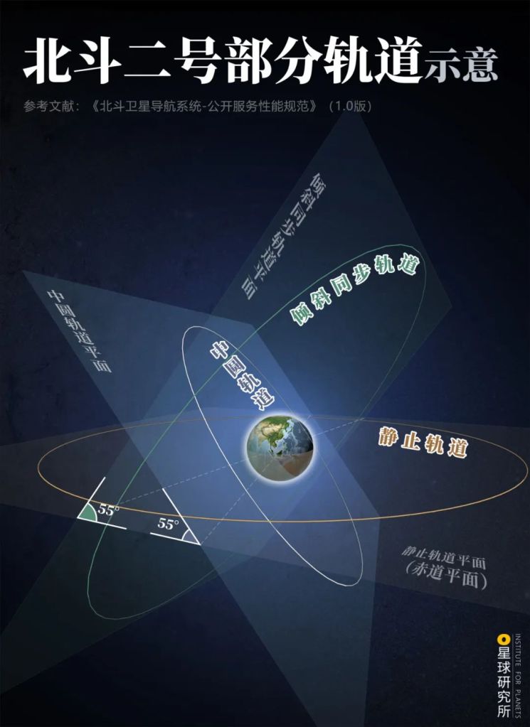
The orbit cycle and altitude of IGSO satellites are the same as GEO satellites
China was the first to use IGSO satellites for navigation
(diagram: 郑伯容, Institute for Planets)
Now moving on to the next challenge in line: positioning accuracy.
Since electromagnetic signals travel at the speed of light, a clock error of merely 1 nanosecond (1 billionth of a second) can result in a distance error of 0.3 metre. The positioning accuracy of a navigation system therefore depends heavily on the accuracy of onboard atomic clocks, as well as time synchronisation between the satellites, ground station and the user.
Commonly used space-borne atomic clock requires an accuracy of 1 part in 1013, that is an error of 1 second every 100,000 years. Back then when BeiDou-2 was under construction, such technology was possessed only by the United States, Russia and Switzerland.
(photo: NASA)
The atomic clock on BeiDou-1 was imported from Switzerland, but the agreement to import more atomic clocks for BeiDou-2 was interrupted and eventually called off. Left with no choice, Chinese scientists had to race against time and start developing their own atomic clock.
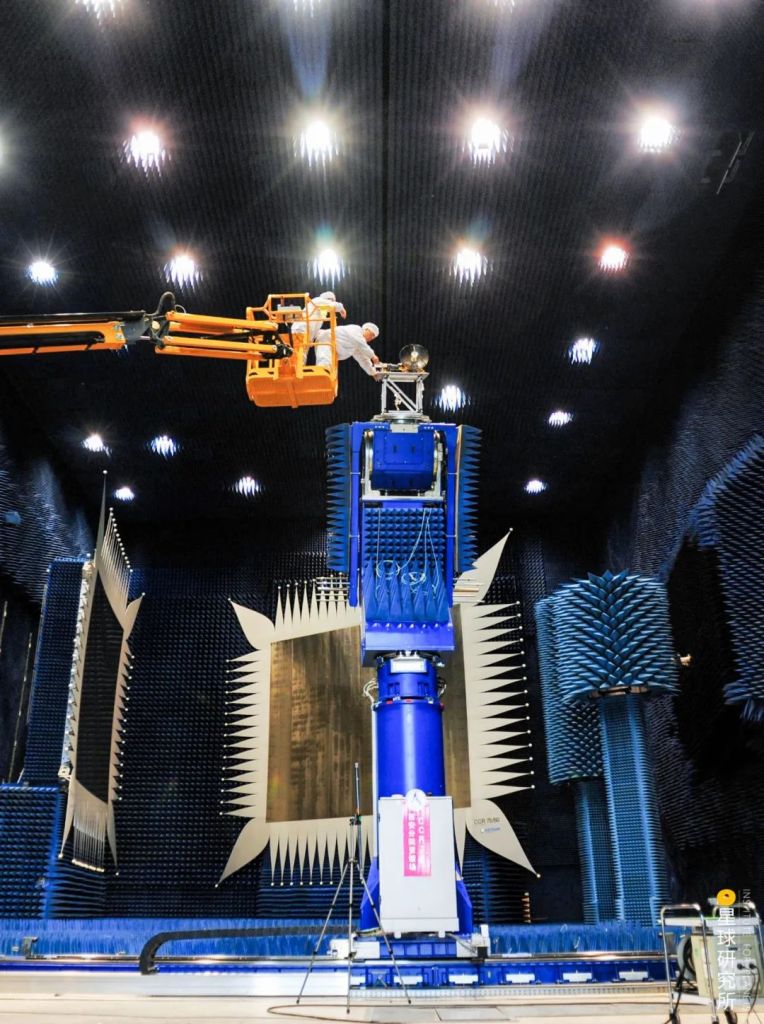
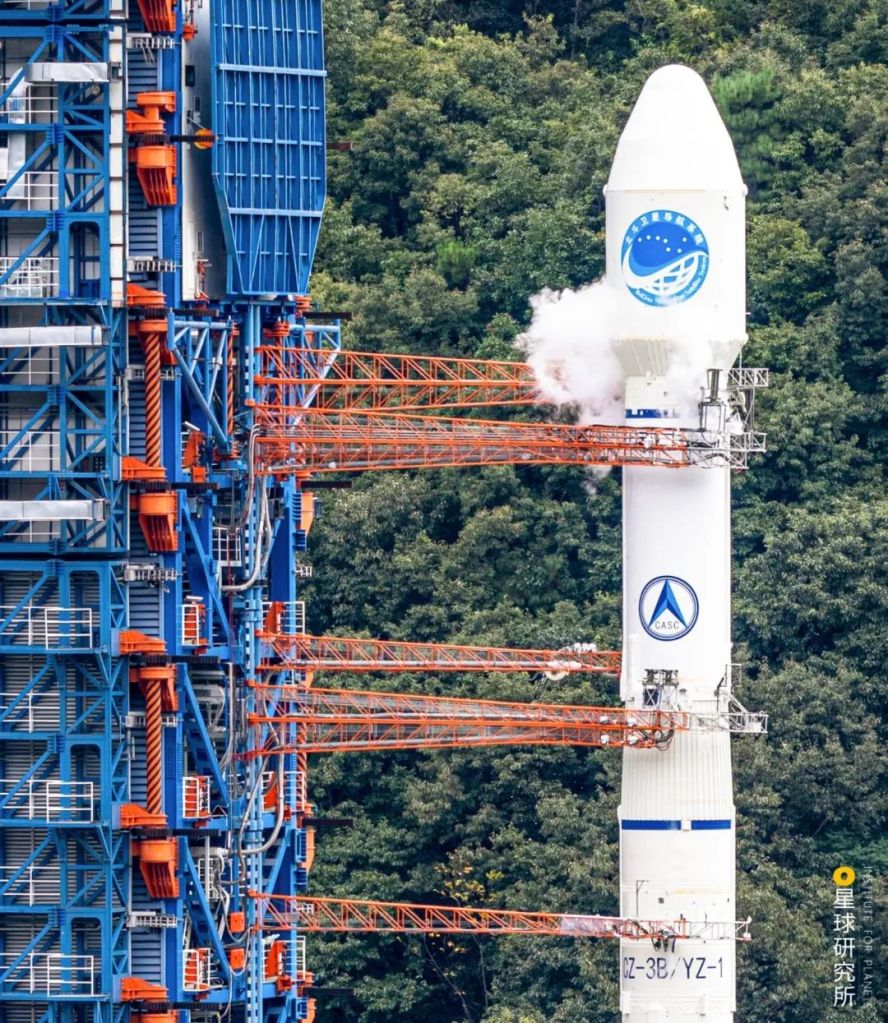
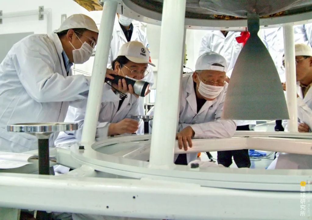
Satellites and launch vehicles of the BeiDou system were developed by China Academy of Space Technology and China Academy of Launch Vehicle Technology respectively; both are subordinate bodies of the larger China Aerospace Science and Technology Corporation
(photo: 苟秉宸)
This was an urgent task because of yet another challenge: launch period.
According to the regulatory framework of the International Telecommunication Union, application for satellite orbit and frequency band assignment must be submitted beforehand, and once approved, the satellite must be brought into full operation within 7 years, otherwise the assignment will be retracted.
China received the application approval for BeiDou-2 on 18 April 2000. This meant that in the coming 7 years, scientists could not afford even one major hiccup.
Stretching at the edges of the image is due to wide-angle shooting
(photo: 南勇)
They worked around the clock, performing all sorts of experiments and troubleshooting. Thanks to their dedication, all the necessary technologies for satellite launching and atomic clock operation were mastered within 7 years and 2 years respectively. More impressively, they managed to spot a last-minute unexpected failure before launching, retrieved the satellite, debugged and reinstalled it back on the rocket, all done within 10 days or so.
Second from the right is Sun Jiadong, the chief designer of BeiDou-1 and 2, also a member of the International Academy of Astronautics and Chinese Academy of Sciences
(photo: 南勇)
It was only 4 hours away from the retraction deadline for the orbit assignment when scientists finally started receiving signals from BeiDou-2 at 8 pm on 17 April 2007.
After enduring years of pioneering hardship and breaking through the technological blockade, China finally built her own satellite navigation system that covers the entire Asia-Pacific. She was just one step away from achieving global coverage.
4. Navigation dragnet
This final step was a comprehensive upgrade of the previous systems.
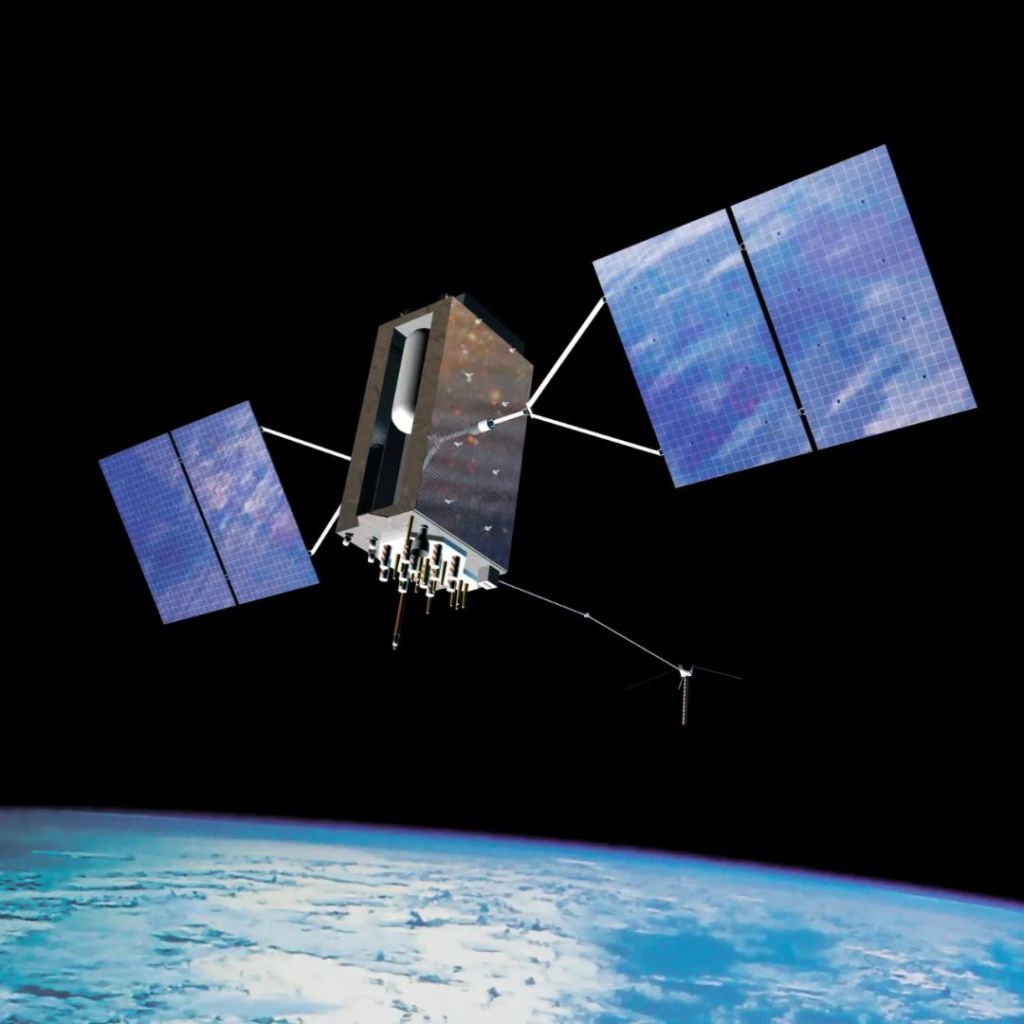
BeiDou-3 satellites have a service life of 10 years, which is 2 years longer than their predecessors. All of their components are domestically designed and manufactured. Notably, after years of continuous advancement in atomic clock technology, these clocks can now operate at an uncertainty of 1 second every 10 million years.
Besides, rocket technology was no longer a limitation for Chinese engineers in recent years, and ‘launching two satellites with one rocket’ was almost a routine:
2017 – 2 satellites launched with 1 rocket
2018 – 17 satellites launched with 9 rockets
2019 – 8 satellites launched with 6 rockets
2020 – 3 satellites launched with 3 rockets
The BeiDou-3 satellite constellation was completed at an unprecedented speed, where 30 satellites were launched into orbit within less than 3 years.
(photo: 史悦)
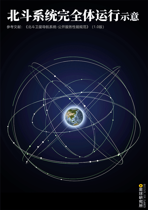
Today in space, there are 3 GEO satellites orbiting above the equator, 3 IGSO satellites providing stable coverage for Asia-Pacific and 24 MEO satellites revolving nonstop around Earth. Together they form an enormous constellation spread out in space like a colossal net of the heavens.
The dream of having a navigation system with global coverage has finally come true. From now on, be it daytime or midnight, and no matter where you are on Earth, just look up into the sky and you will see 5 to 6 BeiDou-3 satellites above your head.
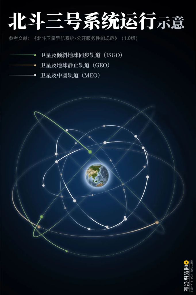
(diagram: 郑伯容, Institute for Planets)
But something is still lacking in BeiDou-3 so far.
When satellites fly past and away from Chinese territories, there is no way to ensure their smooth operation within the designated orbit without coordination by the ground station. Therefore, scientists started constructing inter-satellite links, which are communication bridges among satellites that allow mutual supervision and unmanned maintenance of constellation configuration.
This largely reduces the reliance of the BeiDou-3 system on ground stations. Even if all control units on Earth break down, the constellation can still operate autonomously for up to 60 days.
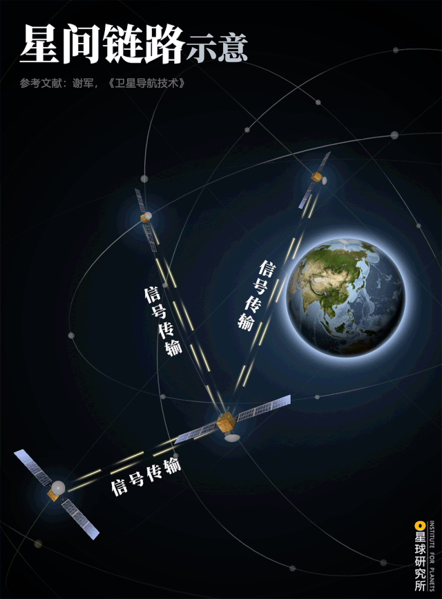
Data transfer (信号传输)
(diagram: 郑伯容, Institute for Planets)
On the ground surface, more than 2700 reference stations and several data processing units are dotted across the vast land of China, forming an elaborate data network that supplements the navigation system with additional ground information, especially when satellite signals are hindered or reflected by terrains or constructions. This supportive system is known as continuously operating reference stations (CORS).
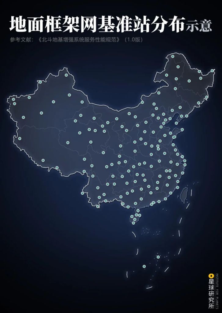
The CORS (地基增强系统) system in BeiDou consists of frame network and regional enhanced density network (区域加强密度网); there are 155 ground stations for the former, and more than 2700 for the latter
(diagram: 王朝阳&郑伯容, Institute for Planets)
Further adjustments and data processing provided by CORS minimise positioning error in the BeiDou navigation system. Accuracy gradually comes down to metre- and decimetre-level, and in some cases even centimetre- or millimetre-level.
This level of accuracy makes it possible to build an electronic fence to make sure all the shared-use bicycles are docked within a specified parking lot.

(photo: VCG)
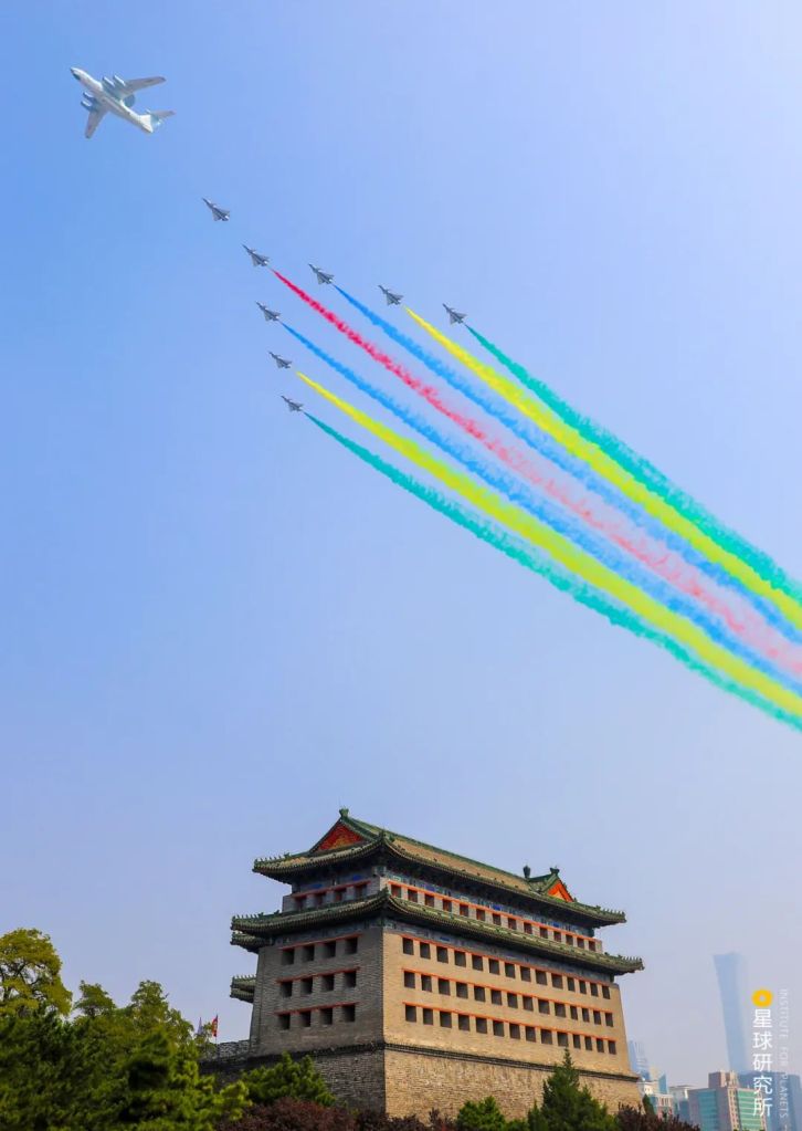
It also allows synchronised marches for various formations and flight echelons in a military parade with a distance error of less than 10 centimetres.
(photo: 拾城 田卫涛)
And helps monitor any deformation in large constructions such as dams and bridges.

There are currently more than 150 monitor units stationed on the slopes on both sides of the dam; they constantly deliver millimetre-level data and report any hidden risk in the dam structure
(photo: 柴峻峰)
Mobile phone chips capable of receiving signals from Beidou are already available commercially. As of Q3 2019, there were almost 300 registered mobile phone models supporting BeiDou navigation system out of a total of little more than 400 models.

(photo: 任炳旭)
These chips can also be installed in vehicles for transportation. By December 2019, more than 6.5 million commercial vehicles, 40,000 postal and express delivery vehicles, 3200 inland river navigation facilities and 2900 maritime navigation systems were equipped with BeiDou navigation system, making it the largest dynamic surveillance system for commercial vehicles and ships.

(photo: 拾城 崔力)
With a dragnet blanketing from space and spreading on the ground, the BeiDou navigation system has now evolved into its ultimate form as BeiDou-3.
5. A 20-year Journey with BeiDou
It took exactly 20 years since the launching of the first BeiDou-1 satellite in 2000 before the last BeiDou-3 satellite flew into orbit in 2020.
For two whole decades, Chinese scientists made the stand and overcame all the hurdles. They took prudent yet progressive steps in developing BeiDou, and fulfilled their bold promise to guide the way first for China, then for Asia-Pacific, and finally for the world.
Today, China celebrates the long-waited completion of her own navigation system. She maintains that BeiDou be open to the whole world, and be integrated in everyday life of more than 7 billion people.

Power transmission lines are equipped with cable fault indicators using BeiDou positioning; this accurately locates the faulty site and allows prompt troubleshooting and repair, thereby minimising power stoppage
(photo: 邱会宁)
Under the wise gaze of BeiDou, pollutants skulking in the air will be constantly monitored by environmental surveillance system.

BeiDou can collect real-time data from atmospheric pollutant monitoring station and communicate the information with the surveillance centre
(photo: 邱会宁)
In the farms, BeiDou can cooperate with agricultural machineries to provide real-time information on cultivation depth and line spacing, which can improve work efficiency by 50% and the yield by 5-8%.

(photo: 邱会宁)
And at the border, particularly among harsh terrains such as mountains and valleys or thick forests, where signal coverage for ordinary communication is lacking, border guards can now deliver vital information in a timely manner with the help of BeiDou.

Positioning and communication functions of BeiDou becomes indispensable in regions where base stations for ordinary communication have no coverage
(photo: 李含军)
But even all these are still far from the true potential of the BeiDou navigation system. As Sun Jiadong, the Father of China’s Satellite and chief designer of BeiDou-1 and 2, had commented:
The key objective of BeiDou is none other than its utilisation. Only when it is more widely used, and its full potential realised, can we say the project has succeeded.
我们建设北斗关键还是在用,只有用得更加普及,更加深入,这才是赢家。
Indeed, the complete configuration of the celestial chessboard merely marks the very beginning of the BeiDou era. Now that BeiDou has finally come out from the Chinese dream into reality, it will embark on the great mission, and serve mankind in every single day that is to come.
Production Team
Text: 艾蓝星
Editing: 桢公子
Photos: 任炳旭
Design: 郑伯容,陈随
Maps: 郑伯容,陈随
Review: 黄超,王朝阳
Expert review
Dr Luo Haiyong (Institute of Computing Technology, Chinese Academy of Sciences)
Acknowledgements
We would like to express our gratitude to Liu Yuncao from the School of Economics and Management, Tsinghua University, for the immense support during the production of this piece.
References
[1]中国卫星导航系统管理办公室. 北斗卫星导航系统发展报告(4.0版), 2019.
[2]中国卫星导航系统管理办公室. 北斗卫星导航系统应用案例, 2018.
[3]谢军,王海红等. 卫星导航技术[M]. 北京理工大学出版社, 2018.
[4]田建波,陈刚. 北斗导航定位技术及其应用[M]. 中国地质大学出版社, 2017.
[5]刘天雄. 卫星导航系统概论[M]. 中国宇航出版社, 2018.
[6]袁树友. 下安物望-北斗应用100例[M]. 解放军出版社, 2017.
[7]王金锋. 空中指南-中国成功发射系列导航卫星[M]. 吉林出版集团, 2009.
[8]《开讲啦:北斗系统总设计师杨长风》,2017.
… The End …

星球研究所
一群国家地理控,专注于探索极致风光

SHIT impressive!! Brilliant. Well done to China.
LikeLike
20 years of brilliant hard work has finally brought China the admiration of the world. Something the people can proud of. Keep it up.
LikeLike